
DAILY FORECAST: Wet and windy today with lots of flood warnings
Published at | Updated at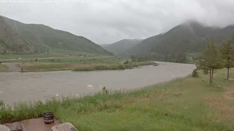
UPDATE:
The National Weather Service has issued a flood watch for the Snake River near Blackfoot. As of noon Tuesday, the river was measuring just below flood stage at 10.1 feet. It is expected to reach flood stage by Thursday.
A flood watch means that flooding is possible, and not imminent.
But flooding is imminent on on the Snake River near Heise. It is measuring below flood stage at 7.5 feet. Additional releases from the Palisades Reservoir this week are expected to push the river above its flood stage of 8 feet. Minor flooding is forecast, especially in the Warm Springs Resort area. The flood warning for the Snake River is in effect for Bonneville, Madison and Jefferson counties.
ORIGINAL STORY:
IDAHO FALLS — It’s going to be a wet and windy day in eastern Idaho for Tuesday, June 13.
The National Weather Service has issued a high wind advisory for most of eastern and central Idaho. Winds of around 30 mph are expected between 7 a.m. to 7 p.m. today. Wind of this speed can make control of high-profile vehicles difficult if in a cross wind situation. When coupled with ground softened by recent heavy rain, this wind can bring down trees with weakened roots or break off weakened tree limbs. Temporary power outages are possible as well.
The wind advisory is in effect for the following cities: Idaho Falls, Rexburg, Rigby, Pocatello, Burley, Rupert and Heyburn.
FLOODING:
Flooding continues to be an issue in eastern Idaho.
The Snake River near Heise is measuring just below flood stage at 7.5 feet. Additional releases from the Palisades Reservoir this week are expected to push the river above its flood stage of 8 feet. Minor flooding is forecast, especially in the Warm Springs Resort area. The flood warning for the Snake River is in effect for Bonneville, Madison and Jefferson counties.
The Big Lost River below the Mackay Reservoir is under a flood warning. It is measuring slightly above flood stage at 4.3 feet and minor flooding is forecast from Leslie to the Darlington Flats.
The Teton River near Driggs is measuring just below flood stage at 4.1 feet. It is expected to rise above flood stage tonight and may reach 4.7 feet by Wednesday. Lowland flooding is expected in the Teton River bottoms from Bates Bridge Sportsman`s access down-river to Idaho Highway 33.
The Big Wood River near Hailey is measuring just below flood stage at 5.6 feet. The river is expected to remain steady today, but will begin rising again on Wednesday. Minor flooding is expected in the Della View subdivision in Hailey.
The Bear River in Bear Lake County is also under a flood warning. The river is measuring at flood stage of 7.5 feet. Minor flooding is occurring on rural roads and in fields and pasture land in the Pegram and Dingle area. Driveways to low lying homes next to the river near Dingle may have water across them.
A significant portion of Fremont, Clark, Teton and Madison counties also are under a flood watch. Moderate to heavy rain on already bank full streams and rivers will cause flooding in some areas.
All streams are already at high flows due to snow melt. Additional precipitation, particularly moderate to heavy amounts, will cause streams in Fremont and Teton county to flood. Fox, Darby, Trail and Badger creeks in Teton County are streams that have flooded in the past and are susceptible to flooding under these conditions.
SEE YOUR COMPLETE EASTIDAHONEWS.COM 10-DAY FORECAST HERE
DAILY FORECAST:
Idaho Falls, Rigby and Rexburg
The Upper Snake River Plain will be rainy and very windy today with highs of 52 to 62 degrees. Southwest winds of 25 to 35 mph are expected. It’ll be cloudy at night with a slight chance of rain and lows of 35 to 42 degrees. Winds will decrease to between 10 to 15 mph.
Pocatello, Fort Hall and Blackfoot
The Lower Snake River Plain will very windy today with lots of rain. Highs of 51 to 60 degrees are expected with southwest winds of 25 to 35 mph. At night it’ll be cloudy with lows of 35 to 45 degrees and decreasing winds of 15 to 25 mph.
St. Anthony, Ashton, Island Park, Driggs and Victor
The Upper Snake Highlands will be rainy and snowy today. Between 2 to 4 inches of snow could fall above 7,400. Highs of 45 to 53 degrees are expected. It’ll be cloudy at night with a chance of rain and lows of 33 to 40 degrees.
Arco, Challis and Mackay
The Lost Rivers area will see rain and snow in the morning and rain in the afternoon. Between 2 and 4 inches of snow could fall above 8,500 feet. Highs of 51 to 61 degrees are expected. It’ll be mostly cloudy in the evening with lows of 33 to 40 degrees.
Henry, Soda Springs, Downey and Lava Hot Springs
The Caribou Highlands will see rain and snow today. It’ll be breezy with possible snow accumulation of 2 to 4 inches above 7,300 feet. Highs of 48 to 58 degrees are expected. It’ll be mostly cloudy in the evening with lows of 33 to 42 degrees.
This weather-related story is brought to you by Frontier Credit Union. At Frontier Credit Union, we believe in building a better life for our members, our communities and the great state of Idaho. Explore our solutions and start building your better life today at Frontier Credit Union.