
‘Absolutely historic’ snow totals forecast for this weekend in several states
Published atChad Myers, CNN Meteorologist

(CNN) — A major snowstorm is on the move and it will severely impact parts of Colorado, Wyoming, Nebraska and South Dakota this weekend. So much so that the National Weather Service in Cheyenne, Wyoming, had some bold words: “The snowfall totals currently forecast are absolutely historic.”
More than 5 million people across this region are under winter weather alerts.
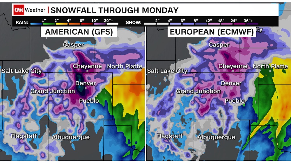
The latest weather models clearly show areas of snow accumulating 20 to 40 inches deep along the foothills and front range from Denver to Cheyenne.
Due to elevation differences, we will see less snow to the east of Interstate 25 and significantly more in the higher elevations to the west.
The heaviest snow in Colorado, Wyoming and Nebraska can come in March, when the air is slightly warmer and can hold more moisture and snow potential. Denver is no stranger to major snowstorms in March, with the Top 10 March snowstorms each totaling over a foot of snow.
The snowstorm this weekend has a “moderate to high potential to surpass the March 23, 2016, heavy snow event,” according to the National Weather Service in Boulder. That day, it snowed 13.1 inches in Denver. NWS Boulder gives a “low to medium potential to approach the March 2003 historical snowstorm,” which dumped 2 to 4 feet of snow across the area.
Storms and forecasts like these — especially potentially historic ones — make meteorologists lose sleep at night.
The biggest obstacle to this forecast is the storm track. Forecast snow amounts can still significantly change if the storm moves north or south of the current projection.
Suppose the track of this low pressure is 100 miles farther north than expected. In that case, Denver will only have minor accumulations … a more southern track would make snow totals go up even higher.
Considering this storm is just moving onshore in California right now, anything is possible.
We often see side-by-side comparisons of the “American Model” versus the “European Model.” They both have extended range forecasts going out 10 days or more.
Both models have agreed to disagree for most of this storm’s history. The American model has shown more snow potential than the European model for many days, at times double.
The closer we get to Saturday, the more accurate the weather models will become. Hopefully, they get to the same conclusion so the forecast can have pinpoint accuracy.
Impossible Travel
This storm will cause life-threatening conditions. Any travel during the height of the storm could have dire consequences.
NWS Boulder is forecasting “snowfall rates of nearly 3 inches per hour in the foothills Saturday night, which means travel would be impossible.”
Heavy snow will combine with strong winds to make white-out conditions at times.
Due to the enormous size of this storm, it’s important to realize the potential impacts go beyond Colorado but also Nebraska, Wyoming and South Dakota.
“We are looking at breaking many snowfall records and major to extreme impacts to southeast Wyoming and Nebraska,” says NWS Cheyenne.
By the time the snowfall ends on Monday, this high-impact storm will have paralyzed some cities, towns and interstate highways.
This will be a significant event that affects people, livestock and pets … now is the time to prepare.
This weather-related story is brought to you by Pony Express Car Wash, Idaho's premier express car wash destination, renowned for its commitment to exceptional service and quality. Voted the No. 1 car wash company in Idaho for three consecutive years, we pride ourselves on delivering an unparalleled experience for every vehicle and customer. Our state-of-the-art facility utilizes name-brand soaps and cutting-edge equipment to ensure your car receives the ultimate clean. Established in eastern Idaho in 2019, Pony Express is proud to be a locally owned and operated company that caters to the unique car washing needs of our Idaho Friends and neighbors. We invite you to experience the difference at Pony Express, where your satisfaction is our ultimate goal.