



Hawaii braces for life-threatening flooding again as El Niño supercharges Pacific hurricane season
Published at
Meteorologists Mary Gilbert, Chris Dolce, CNN
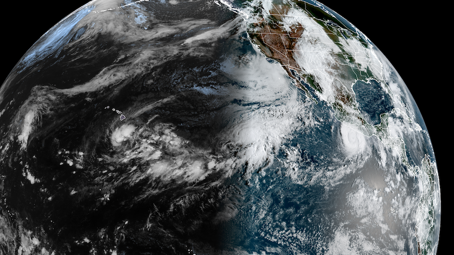
(CNN) — Hawaii will once again face potentially life-threatening flooding and mudslides as Tropical Storm Nolo starts to strengthen and edge closer to the state’s eastern islands.
The Big Island will see the worst of Nolo’s impacts when it makes its closest approach as a hurricane late Friday through Saturday, local time. Extreme rain will be its most serious threat, but Nolo will also bring strong wind and dangerous seas.
It will be the state’s third brush with a hurricane during this year’s Pacific hurricane season, which has been supercharged by a super El Niño’s extremely warm ocean water and lack of storm-killing wind shear.
Hurricane Lala took a similarly close track to the Big Island in mid-August as a Category 1 storm and unleashed catastrophic flooding there. On the other side of the state, Hurricane Lowell delivered a blow to Kauai and Niihau in early September as a Category 2 storm.
If Nolo’s center comes within 100 miles of the Big Island — as it’s currently forecast to — it will be the first time three hurricanes have come that close to Hawaii’s main islands in a single season since at least the 1950s.
Nolo is one of 19 named storms — including three Category 5 hurricanes — have roamed the eastern and central Pacific so far and there are two full months of the season left to go. Seventeen originated in the eastern Pacific basin, which typically sees up to 15 storms in an entire season. One of those Category 5s, Hurricane Polo, is still roaring off the coast of southern Mexico.
Yet another hurricane threatens to inundate Hawaii
Tropical Storm Nolo was strengthening early Thursday morning as it started to slowly track north toward Hawaii. It’s set to pass close to the Big Island as a hurricane Saturday, bringing extreme rain, damaging winds and dangerous surf.
A hurricane watch is in effect for Hawaii County, which encompasses all of the Big Island.
“Life-threatening, catastrophic flooding and mudslides are possible” on portions of the Big Island and Maui, the National Hurricane Center warned Wednesday.
Nolo is forecast to reach hurricane strength by Thursday night local time.
It’s expected to make its closest approach to the Big Island late Friday through Saturday as a high-end Category 2 hurricane or a Category 3 major hurricane.
Nolo’s close pass as a potential major hurricane means damaging winds are a considerable threat. Tropical storm-force winds stronger than 40 mph are likely and hurricane-force winds stronger than 75 mph are possible on the Big Island’s south side Friday through at least Saturday. Stronger gusts are likely in the island’s high elevations.
A flood threat will build well ahead of the system’s closest approach. Rain will begin Thursday on the Big Island and spread to reach Maui, Lanai and Molokai Thursday night or early Friday.
Ten to 15 inches of rain are possible over the Big Island through Sunday with up to 35 inches in the steepest terrain, according to the National Hurricane Center. Mountains force air to rush upwards, wringing out more moisture that falls as torrential rain. Lala dumped more than 40 inches of rain on parts the Big Island and the results were catastrophic.
In Maui, 5 to 10 inches are possible with isolated amounts up to 20 inches. About 1 to 3 inches of rain is expected elsewhere on the main islands.
Offshore, dangerous seas will build and reach their peak Friday and Saturday. Rough conditions will likely last through the weekend and into next week even as the hurricane starts to track west away from the island Sunday night into Monday.
Ferocious Hurricane Polo
Earlier this week, Hurricane Polo showed exactly what the extremely warm Pacific is capable of when it exploded from a tropical storm to Category 5 hurricane in just 24 hours.
That’s called extreme rapid intensification, a wind increase of 58 mph or more in 24 hours. Polo met that criteria and then some, with a 110-mph increase in its sustained winds from Monday to Tuesday morning. More hurricanes are rapidly intensifying as Earth and its oceans warm from fossil fuel pollution.
Polo’s winds topped out at 180 mph on Tuesday afternoon, tying a pair of super typhoons in the West Pacific as the strongest storms on the planet so far this year.
The hurricane regained its Category 5 status Wednesday evening after spending about a day as a Category 4. As of Thursday morning, it was still a Category 5, located about 100 miles offshore of southern Mexico’s state of Guerrero.
Polo won’t make landfall there, but it is bringing rain and strong winds to parts of the coast. Heavy rain is Polo’s most significant threat and could cause life-threatening flooding and mudslides in this region.
Rainfall totals in coastal Guerrero and Michoacán states could reach 3 to 6 inches, with locally up to 8 inches in spots through Thursday. Coastal portions of Oaxaca, Colima and Jalisco states could receive 2 to 4 inches of rain.
This weather-related story is brought to you by Pony Express Car Wash, Idaho's premier express car wash destination, renowned for its commitment to exceptional service and quality. Voted the No. 1 car wash company in Idaho for five consecutive years, we pride ourselves on delivering an unparalleled experience for every vehicle and customer. Our state-of-the-art facility utilizes name-brand soaps and cutting-edge equipment to ensure your car receives the ultimate clean. Established in eastern Idaho in 2019, Pony Express is proud to be a locally owned and operated company that caters to the unique car washing needs of our Idaho Friends and neighbors. We invite you to experience the difference at Pony Express, where your satisfaction is our ultimate goal.