
‘Dangerous wind chills!’ Record-breaking cold temperatures expected in eastern Idaho this week
Published at | Updated at
The following is a special weather statement from the National Weather Service.
IDAHO FALLS — An arctic cold front will drop quickly south from Canada and move through Idaho Monday night. Very cold temperatures and light snow will accompany the front and a half-inch to up to three inches of snow may fall with this very cold system.
Roads may possibly be snow-covered and slippery for rush hour traffic Tuesday morning.

Everyone traveling late Monday night through Tuesday morning should prepare for very cold temperatures, potential snowfall and slippery roads.
Affected areas include Shoshone, Richfield, Carey, Mud Lake, INL, Craters of the Moon NM, Idaho Falls, Rexburg, St. Anthony, Pocatello, Blackfoot, American Falls, Shelley, Fort Hall, Burley, Rupert, Heyburn, Oakley, Inkom, McCammon, Downey, Lava Hot Springs, Grace, Soda Springs, Henry, and Bone.
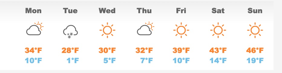
The latest weather information and 7 day forecast can be found here.
This weather-related story is brought to you by Pony Express Car Wash, Idaho's premier express car wash destination, renowned for its commitment to exceptional service and quality. Voted the No. 1 car wash company in Idaho for three consecutive years, we pride ourselves on delivering an unparalleled experience for every vehicle and customer. Our state-of-the-art facility utilizes name-brand soaps and cutting-edge equipment to ensure your car receives the ultimate clean. Established in eastern Idaho in 2019, Pony Express is proud to be a locally owned and operated company that caters to the unique car washing needs of our Idaho Friends and neighbors. We invite you to experience the difference at Pony Express, where your satisfaction is our ultimate goal.