
Is spring flooding a concern in eastern Idaho this year?
Published at | Updated at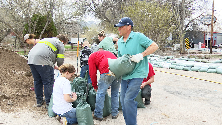
POCATELLO — As the spring flood season approaches, emergency officials are reminding people to prepare for any flooding that could happen.
Though flooding isn’t likely to occur in many parts of eastern Idaho, it’s always a possibility, especially for areas near rivers and low-lying elevation.
The two types of flooding emergency managers watch for are river floods and flash floods. River floods are caused by snowmelt while flash floods are brought on by heavy precipitation.
Jefferson County Emergency Manager Rebecca Squires says flash floods can happen suddenly and end just as quickly.
“That flooding is usually very, very intense but very short lived,” Squires says.
River flooding is dependent on how fast temperatures climb. Mid-march through Mid-april is when the region sees its peak snowpack levels. If it gets too hot too soon, snow melts faster.
How warm it is at night plays a role in river flooding as well because it gives the city infrastructure and river systems a break without adding new snow melt.
RELATED | It was a record-breaking weather weekend in Pocatello
Recently, the Portneuf Valley saw around 10 to 12 inches of heavy wet snow during a late winter storm. Since temperatures have been dropping back to freezing during the night, it hasn’t caused any flooding.
“We’re kind of melting that snow off in a polite manner,” said Tim Axford, meteorologist at the National Weather Service in Pocatello. “It’s not gonna come off all at once just because we’re getting into the 50s. It’s gonna take several weeks.”
Squires doesn’t anticipate any flooding in Jefferson County this year because the snow water equivalent and snow pack levels are close to average.
Brad Clements, Bonneville County’s director of emergency management, feels similarly but says it’s still possible.
“Depending on how much snow melts off this week, that’s what will really affect it,” Clements said.
Wes Jones, director for the Office of Emergency Management in Bannock County, said that while it’s highly likely the county’s flood prone areas will see flooding, it’s not likely to become a major flood.
One of these flood prone areas is the city of Inkom in the low-lying areas near Rapid Creek. Last year, members of the community banded together to set up sandbags across the bridge entering town and direct the flood waters away from nearby businesses.
RELATED | Inkom community comes together to mitigate flooding
“Rapid Creek runs through the heart of our town and that’ll be our biggest concentration,” Inkom Mayor Max Shaffer says. “The places on Rapid Creek that have been problematic before are gonna be problematic again.”
If the temperature increase is gradual over the next few weeks, the less severe the flooding will be, he says.
The city will set up sandbags along the river preemptively in flood prone areas like they did last year.
“I’m sure that’s on everyone’s mind … and we’ll be pursuing that again soon to make sure we’re ready,” Shaffer said.
Other people in flood prone areas can also do this to try and prevent property damage. Bannock County plans to stage sandbag pickup locations like they did last year.
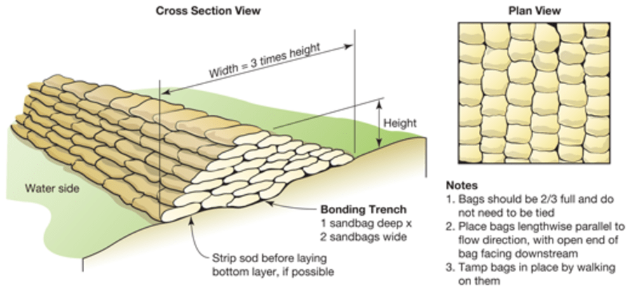
Those filling up sandbags should only fill them halfway so water doesn’t flow through gaps. The sandbags should be stacked like a pyramid. The Bonneville County website includes a link to a guide by the US Army Corps of Engineers.
This weather-related story is brought to you by Pony Express Car Wash, Idaho's premier express car wash destination, renowned for its commitment to exceptional service and quality. Voted the No. 1 car wash company in Idaho for three consecutive years, we pride ourselves on delivering an unparalleled experience for every vehicle and customer. Our state-of-the-art facility utilizes name-brand soaps and cutting-edge equipment to ensure your car receives the ultimate clean. Established in eastern Idaho in 2019, Pony Express is proud to be a locally owned and operated company that caters to the unique car washing needs of our Idaho Friends and neighbors. We invite you to experience the difference at Pony Express, where your satisfaction is our ultimate goal.