
The West’s historic drought in 3 maps
Published at | Updated atJohn Keefe and Rachel Ramirez, CNN
(CNN) — An unprecedented, multi-year drought continues to worsen in the West amid a period of record heat and dryness, which scientists say is a clear sign of how the climate crisis is affecting not only the weather, but water supply, food production and electricity generation.
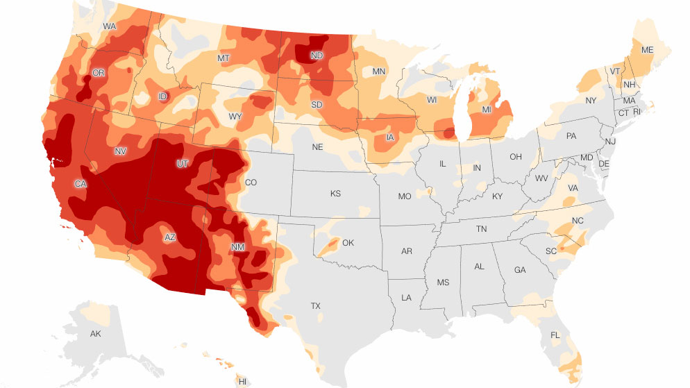
The drought has expanded in the West where “rapid deteriorations” in conditions were seen, according to the US Drought Monitor. More than 94 percent of the West is in some level of drought, with more than two-thirds in extreme or exceptional drought — the two worst categories.
Six states are now entirely in drought conditions.
Across the US, the drought has nearly doubled in size from this time last year. Around 25% of the country was in drought conditions in July 2020; as of this week, nearly half is in drought.
In addition to mandatory water restrictions already in place, even stricter cuts are looming amid the drought in some states as water levels plummet along the Colorado River.
Climate change is playing a key role in these compounding crises: Drought and extreme heat are fueling wildfires; reduced snowpack and the lack of substantial precipitation are exacerbating water demands for millions of people, as well as agriculture, ecosystems and deteriorating infrastructure.

Current drought
More than 94% of the West is in drought, the largest area on record. More than 60% of the region is in ‘extreme’ or ‘exceptional’ drought — the two most severe categories — expanding by 35,000 square miles, or roughly the size of the state of Indiana.
There are six states completely in drought conditions; California, Oregon, Nevada, Utah, Idaho and North Dakota.
For the second week in a row, conditions deteriorated in the Pacific Northwest. Oregon’s current conditions are among the driest since the late 1800s, according to the US Drought Monitor. In Washington, “rangeland and pasture conditions are far worse this year when compared to all other years this century,” it reported.
The National Weather Service noted it’s the first time the state of Washington has been in exceptional drought since the Drought Monitor began in 2000.
The Big Lost River in Idaho “is almost out of storage,” the Drought Monitor reported last week, and there is “significant agricultural impacts to the state, including crop loss, a lack of forage, and animal deaths.”
Conditions improved somewhat in the Southwest, namely in New Mexico, thanks to enhanced rainfall from the Southwest monsoon.
As the planet warms, drought and extreme heat will also fuel deadly wildfires. Multiple studies have linked rising carbon dioxide emissions and high temperatures to increased acreage of burning across the West, particularly in California.

Rainfall outlook
The West experienced extremely low rain and snowfall over the past year, compounded by drastically high temperatures. Less rain and increasing heat waves have led directly to drought conditions and water shortages.
The Southwest monsoon, which began in mid-July, is expected to lead to some relief in that region. The Drought Monitor reports recent rain “has resulted in drastic improvements in recent weeks” in New Mexico. In some cases, the agency reports, “moisture has seeped several feet into the soils.”
As climate change accelerates and winter temperatures increase, snowfall will decrease. High-elevation snowpack serves as a natural reservoir that eases drought, storing water through the winter months and slowly releasing it through the spring melting season.
Stream and river flow
Streamflow, a measure of how much water is carried by rivers and streams, is another significant indicator of drought and its impact.
As drought conditions have worsened in 2021, hundreds of stream and river locations are experiencing below-average flow. More than 50 percent of the western monitoring stations reported lighter-than-usual flows. Fishing restrictions have also been put in place on many rivers in Montana due to low flows and warm waters.
Changes in streamflow affect the water supply for our own municipal use, crop irrigation and power generation.
The-CNN-Wire
™ & © 2021 Cable News Network, Inc., a WarnerMedia Company. All rights reserved.
This weather-related story is brought to you by Pony Express Car Wash, Idaho's premier express car wash destination, renowned for its commitment to exceptional service and quality. Voted the No. 1 car wash company in Idaho for three consecutive years, we pride ourselves on delivering an unparalleled experience for every vehicle and customer. Our state-of-the-art facility utilizes name-brand soaps and cutting-edge equipment to ensure your car receives the ultimate clean. Established in eastern Idaho in 2019, Pony Express is proud to be a locally owned and operated company that caters to the unique car washing needs of our Idaho Friends and neighbors. We invite you to experience the difference at Pony Express, where your satisfaction is our ultimate goal.