
Heavy snow and wind expected after winter storm warning issued
Published at | Updated at
POCATELLO — A winter storm warning and winter weather advisory are in effect for a large section of eastern Idaho from Thursday night into the weekend.
Snow and wind are expected throughout the region, which might make travel very difficult in some areas. The National Weather Service says the warning and advisory go into effect at 11 p.m. Thursday through 5 p.m. Saturday.
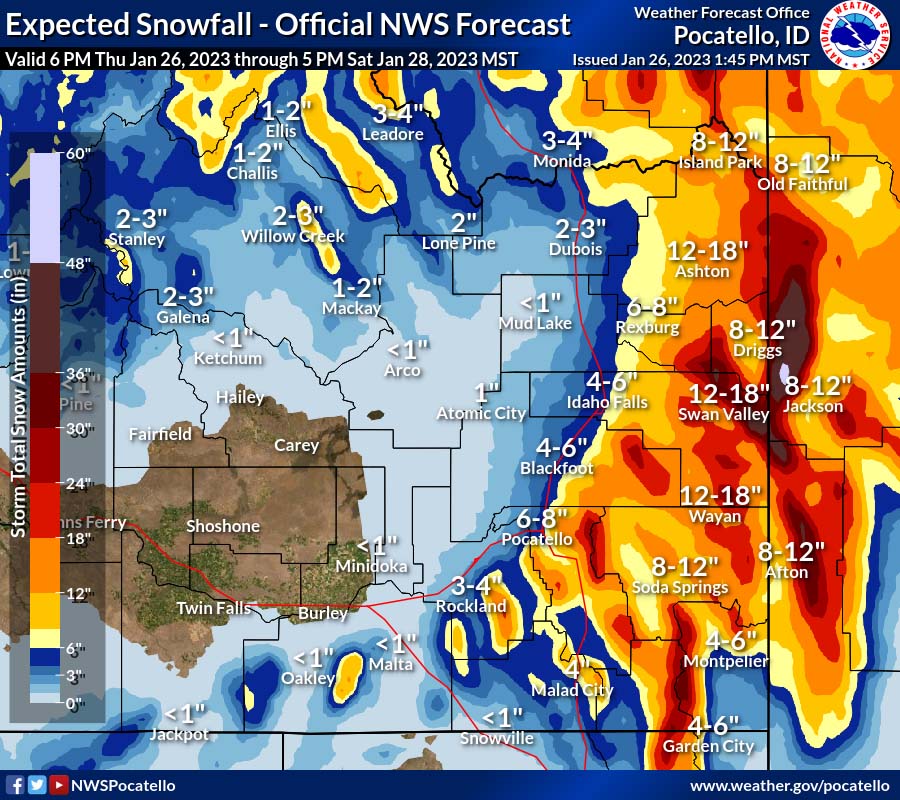
One area under the winter storm warning includes Victor, Driggs, Tetonia, Ashton, Island Park, Pine Creek Pass, Targhee Pass and Raynolds Pass. The snow will be moderate to heavy at times. There could be total snow accumulations of six to 12 inches in the region.
Additionally, there could be five to nine inches of snow in the areas surrounding Inkom, McCammon, Downey, Lava Hot Springs, Emigration Summit, Grace, Soda Springs, Henry, Bone, Wayan and Swan Valley, according to the National Weather Service.
Winds of 35 mph are expected to cause blowing snow, which will significantly reduce visibility.
“If you must travel, keep an extra flashlight, food, and water in your vehicle in case of an emergency,” the warning said.
The less severe winter weather advisory is in effect for Idaho Falls, Rexburg, Rigby, Ririe, St. Anthony, Pocatello, Blackfoot, American Falls, Shelley, Fort Hall, Malad, Preston, Thatcher, St. Charles, Montpelier and Georgetown. People living in those areas could see snow accumulations of four to eight inches with wind gusts of 35 mph.
Click here to monitor the latest forecasts, and click here for the latest road conditions.


This weather-related story is brought to you by Pony Express Car Wash, Idaho's premier express car wash destination, renowned for its commitment to exceptional service and quality. Voted the No. 1 car wash company in Idaho for three consecutive years, we pride ourselves on delivering an unparalleled experience for every vehicle and customer. Our state-of-the-art facility utilizes name-brand soaps and cutting-edge equipment to ensure your car receives the ultimate clean. Established in eastern Idaho in 2019, Pony Express is proud to be a locally owned and operated company that caters to the unique car washing needs of our Idaho Friends and neighbors. We invite you to experience the difference at Pony Express, where your satisfaction is our ultimate goal.