
Brace for more wind: Another powerful, more widespread storm headed for east Idaho
Published at | Updated at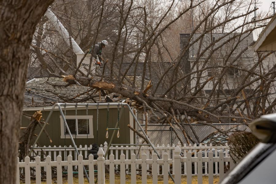
POCATELLO — Batten down the hatches! As if Thursday’s powerful windstorm wasn’t enough, forecasters say another round is headed for east Idaho this weekend.
And the wind gusts could do even more damage.
Audra Moore, a meteorologist with the National Weather Service in Pocatello, said the system will be similar to Thursday’s storm but will affect a much larger area and bring stronger gusts.
RELATED | Strong winds causing road closures, property damage throughout eastern Idaho
“Thursday’s extreme high winds were mostly confined to the Idaho Falls area. But on Saturday, everyone will get in on the action,” Moore said. “That includes Rexburg, Pocatello, American Falls and Burley — with the strongest winds expected between noon and 9 p.m.”
According to the National Weather Service, southwest winds of 25 mph to 35 mph, with gusts up to 50 mph, were expected Friday under a wind advisory. On Saturday, west winds are forecast to increase to 35-45 mph, with gusts up to 65 mph.
Moore predicts gusts could even reach 75 mph in some areas.
Forecasters have also issued a Blowing Dust Warning for the Upper Snake River Plain from noon to 9 p.m. Saturday, which could create severely limited visibility and dangerous travel conditions.
Strong crosswinds will make travel dangerous for high-profile vehicles

Officials warn that blowing dust may cause sudden drops in visibility to near zero, making travel hazardous or even life-threatening. Drivers of high-profile vehicles such as semitrucks, RVs and trailers may experience especially dangerous conditions.
“The last blowing dust warning in the area was issued in April 2020,” Moore noted.
Isolated damage to trees, power lines, signs and outbuildings is possible, and scattered power outages could occur. Loose outdoor objects may also be blown around by the strong winds.
People with respiratory conditions are encouraged to stay indoors during the storm due to dust in the air.
If drivers encounter blowing dust on the roadway, the National Weather Service recommends pulling off the road as far as possible, placing the vehicle in park, turning off all lights and keeping your foot off the brake pedal. The agency reminds motorists to “Pull Aside, Stay Alive.”
Residents are also encouraged to secure or bring inside loose outdoor items before the winds arrive.
“Enjoy the calm before the storm, and take the time to go outside and pin down or bring inside anything you don’t want to blow away,” Moore said.
GALLERY | Here are your wind damage photos from Thursday’s storm
Officials also recommend avoiding forested areas or locations near trees and power lines during the strongest winds.
Drivers who must travel should keep both hands on the steering wheel and use extra caution. High-profile vehicles may want to consider delaying travel until winds subside.
The National Weather Service in Pocatello advises residents to monitor forecasts for updates as the storm approaches.
For the latest information on weather where you live, check out the EastIdahoNews.com Weather page.
This weather-related story is brought to you by Pony Express Car Wash, Idaho's premier express car wash destination, renowned for its commitment to exceptional service and quality. Voted the No. 1 car wash company in Idaho for three consecutive years, we pride ourselves on delivering an unparalleled experience for every vehicle and customer. Our state-of-the-art facility utilizes name-brand soaps and cutting-edge equipment to ensure your car receives the ultimate clean. Established in eastern Idaho in 2019, Pony Express is proud to be a locally owned and operated company that caters to the unique car washing needs of our Idaho Friends and neighbors. We invite you to experience the difference at Pony Express, where your satisfaction is our ultimate goal.